1st GEODETA 2019
Geospatial for Land and Marine Sustainable Development
Click on the link below to download the document:
Event Details
1st GEODETA 2019
Geospatial for Land and Marine Sustainable Development
In this conference there will be activities in the form of scientific seminars, both oral and poster presentations. The conference will be held with panel plenary activities consisting of keynote speakers and invited speakers. Speakers presented included elements of education (academia), scientific (researchers)) both from Indonesia and from International as well as industry / private. After the invitation speaker, then a parallel oral presentation was held and poster presentations from conference participants.
When
-
Wednesday and Thursday 24 – 25 Juli 2019
Venue
-
Hotel Santika Premiere Semarang Jl. Pandanaran No. 116 – 120 Semarang 50134
Topics & Scopes
1. Geodesy and Geodynamic
- Geodetic Reference System
- Vertical reference System
- Tectonics Deformation Monitoring
- Global Navigation Satellite System (GNSS)
- Atmospherics Modeling
2. Survey and Mapping Technology
- Remote sensing, and Photogrametric
- Unmanned Aerial Vehicle, Autonomous Surface Vessel, and Remotely Operated
Vehicle - Terrestrial survey equipment
- Mapping Software development
- Training and Education
- Participatory Mapping
3. Land and Marine Cadastre, and Regional and Urban Planning
- Land Administration
- Landreform
- Regional and National Boundaries
- Regional and Urban Planning
4. Hidrography and Oceanography
- Tide and Sea Level Rise
- Offshore Survey
- Coastal Management
5. Geographic Information Science
- GIS application for Human and Environment
- Spatial Data Infrastructure
- WebGIS, Mobile GIS, and Geoportal
6. Disaster Management
- Natural Disaster
- Mitigation
- Risk Mapping
7. Civil and Environmental Engineering Survey
- Quantity Surveying
- Building Information Modeling (BIM)
- Underground utility Mapping
- Building deformation monitoring
Important Dates
| Abstract Submission Deadline | 19 May 2019 |
| Acceptance Notification | 31 May 2019 |
| Early Bird Registration | 14 June 2019 |
| Full Text Submission | 30 July 2019 |
| GEODETA Conference | 24-25 July 2019 |
Output
Proceedings in International scientific journals (KnE) indexed by Scopus
ISSN national online journal and indexed by DOAJ in Undip’s Ellipsoida Geodetic Engineering Journal
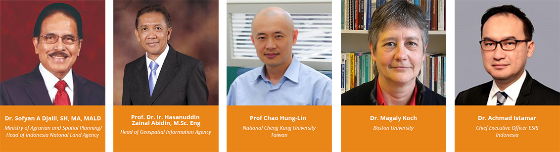
Keynote Speakers
Registration Fees
| Categories | Early Bird | Normal | |
| National Participant | Participant Non-Author | IDR 500,000 | IDR 750,000 |
| Student Authors | IDR 2,000,000 | IDR 2,500,000 | |
| Non-Student Authors | IDR 2,500,000 | IDR 3,000,000 | |
| International Participant | Participant Non-Author | USD 75 | USD 100 |
| Student Authors | USD 150 | USD 175 | |
| Non-Student Authors | USD 200 | USD 250 | |
Contact Us
Gedung Kuliah Bersama (GKB) Lt.3 Fakultas Teknik Universitas Diponegoro Departement of Geodetic Engineering
Dr. Yudo Prasetyo (+62 8112744779 ; yudo.prasetyo@ft.undip.ac.id)
Dr. L.M. Sabri (+62 82325185515 ; lmsabri@ft.undip.ac.id)
Moehammad Awaluddin, ST., MT (+62 8156662676; Awal210874@gmail.com)
Hana Sugiastu Firdaus, ST., MT (+62 81232057594 ; hanasugiastufirdaus@gmail.com)
E-mail: geodeta@ft.undip.ac.id